Home
Pucon Trekking/Hiking Trail Map Atlas Villarrica & Huerquehue National Parks Chile Araucania Villarica National Reserve El Cani Sanctuary Quetrupillan Volcano 1: 50000: Trails, Hikes & Walks Topographic Map
Barnes and Noble
Loading Inventory...
Pucon Trekking/Hiking Trail Map Atlas Villarrica & Huerquehue National Parks Chile Araucania Villarica National Reserve El Cani Sanctuary Quetrupillan Volcano 1: 50000: Trails, Hikes & Walks Topographic Map in Franklin, TN
Current price: $14.95
Barnes and Noble
Pucon Trekking/Hiking Trail Map Atlas Villarrica & Huerquehue National Parks Chile Araucania Villarica National Reserve El Cani Sanctuary Quetrupillan Volcano 1: 50000: Trails, Hikes & Walks Topographic Map in Franklin, TN
Current price: $14.95
Loading Inventory...
Size: OS
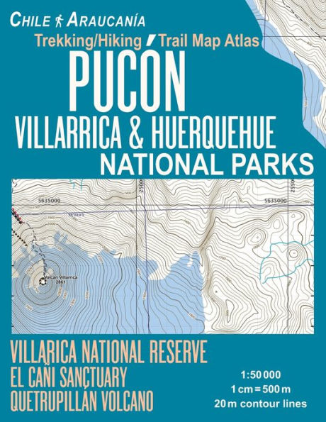
Updated edition. Complete map of the Villarica & Huerquehue National Parks, Villarica National Reserve & El Cani Sanctuary in Chile, Los Lagos region, covering great walks and wonderful hiking trails in the area. Detailed topographic map 1:50.000 & 20 meter contours for hiking and trekking, printed as an atlas book (with overlapping pages).
Covers the full area of the Villarrica National Park, including Mirador Los Cráteres, Pichillancahue, Los Nevados, Valle Turbio, Quetrupillán Ascent, Villarrica Traverse Trail, Chinay, Puesco, etc. The complete area of the Huerquehue National Park including Los Lagos Trail, Quinchol & San SebastiánThe maps also fully cover the Villarrica National Reserve with Laguna Huesquefilo and some part of Argentina with Lanin Volcano, etc.
20 meter contour lines, road network, trails & paths, transportation, food, campsites, shelters, guest houses & hotels.Mercator projection with both UTM and WGS84 coordinate grids.
The map scale of 1:50000 (1 cm = 500 meters) provides a wealth of detail while keeping low the weight of the atlas itself. The large page format of 8.5x11in minimizes page count and along with an overlapping map design allows for comfortable navigation.
The details included in the topographic maps of this atlas were specifically selected to be useful for trekkers, hikers and walkers of all interests, and make it easy to plan and enjoy both short excursions and hikes as well as long multi-day adventures along the main marked routes and/or adjacent trails and paths, which are also shown on the maps.
With this ultralight atlas you will always have a detailed, reliable, information-rich, battery-independent, shatter-proof map for your adventure.