Home
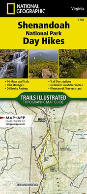
Shenandoah National Park Day Hikes Map
Barnes and Noble
Loading Inventory...
Shenandoah National Park Day Hikes Map in Franklin, TN
Current price: $14.95
Barnes and Noble
Shenandoah National Park Day Hikes Map in Franklin, TN
Current price: $14.95
Loading Inventory...
Size: OS
• Waterproof • Tear-Resistant • Topographic Map
Shenandoah National Park rises above the Virginia Piedmont to its east and the Shenandoah Valley to its west, with two peaks, Stony Man and Hawksbill, exceeding 4,000 feet. The park hosts over 500 miles of trails, including 101 miles of the Appalachian National Scenic Trail. Trails lead to beautiful, cascading waterfalls, stunning panorama viewpoints, and explore deep into the forest and wilderness.
The
Shenandoah National Park Day Hikes
Topographic Map Guide
includes sixteen diverse hikes for all hiking enthusiasts, from the easy, 3.0 mile long Stony Man Loop to the strenuous, 9.4 mile long Wildcat Ridge-Chimney Rock Loop. Each hike has a detailed map, a trail profile visualizing the changes in elevation, and a short summary of the interesting features encountered along the trip.
Some of the must-visit sites in this
are: Overall Run Falls—the largest waterfall in Shenandoah National Park at 93 feet, Compton Peak—two scenic viewpoints and a unique columnar jointing geologic feature, and Jones Run Falls—a 42-foot cascading waterfall surrounded by ancient rocks and moss.
More convenient and easier to use than folded maps, but just as compact and lightweight, National Geographic's
booklets are printed on "Backcountry Tough" waterproof, tear-resistant paper with stainless steel staples. A full UTM grid is printed on the map to aid with GPS navigation.
Map Scale = 1:31,680
Folded Size = 4.25" x 9.38"
![Shenandoah Day Hikes and National Park Map [Map Pack Bundle]](https://prodimage.images-bn.com/pimages/9781566958332_p0_v1_s600x595.jpg)
![Big Bend Day Hikes and National Park Map [Map Pack Bundle]](https://prodimage.images-bn.com/pimages/9781566959124_p0_v1_s600x595.jpg)
